Tech & Apps
Tech & Apps
ML Infomap is a one-stop-shop for developing GIS solutions for informed decision making and ease of operations. With over three decades of experience in the geospatial sector, we are able to provide technological expertise and unmatched support to clients in their digital transformation experience in planning, implementation and operational functions.
We develop real-time location-based apps for countrywide asset management and field operations. We have powerful enterprise solutions for road and railway transportation, management of the skills development ecosystem, health environment, digital mapping and imagery data processing.
Our solutions offer complete automated work flows to ensure routine work is conducted smoothly. All routine functions like generation of orders, approvals, compliances, reports, alerts and contractual billing are all possible from our unified GIS platform.
We design and develop GIS solutions on ESRI technology and Open Source.
We design and develop Apps on Cloud, Desktop & Mobile platforms.
- • Our Technology strengths are in modeling, cloud computing, database, data analytics, AI:ML processing satellite and drone images, Mixed Reality, full stack Web app development.
- • Our extensive Platform Experience includes AWS and Azure for cloud, and Android and iOS for mobiles.
- • Our System Integration capabilities include linking apps, platforms & technologies like GPS, images, database, SAP, video and other sensors.
- • Our IT/GIS solutions cover fleet management, management of healthcare and skills environment, digitizing, 3D visualization, pattern and change detection using AI:ML.
We have strong in-house programming capabilities. We offer:
- • MERN & MEAN Stack Development
- • Technology: .NET, Python, JavaScript, Java, PHP
- • Databases: MS SQL, Mongo, Dynmo, Postgres, Oracle, MySQL
USE CASES: PROBLEM SOLVING WITH GEOSPATIAL TECHNOLOGY
The Skills India Digital Project
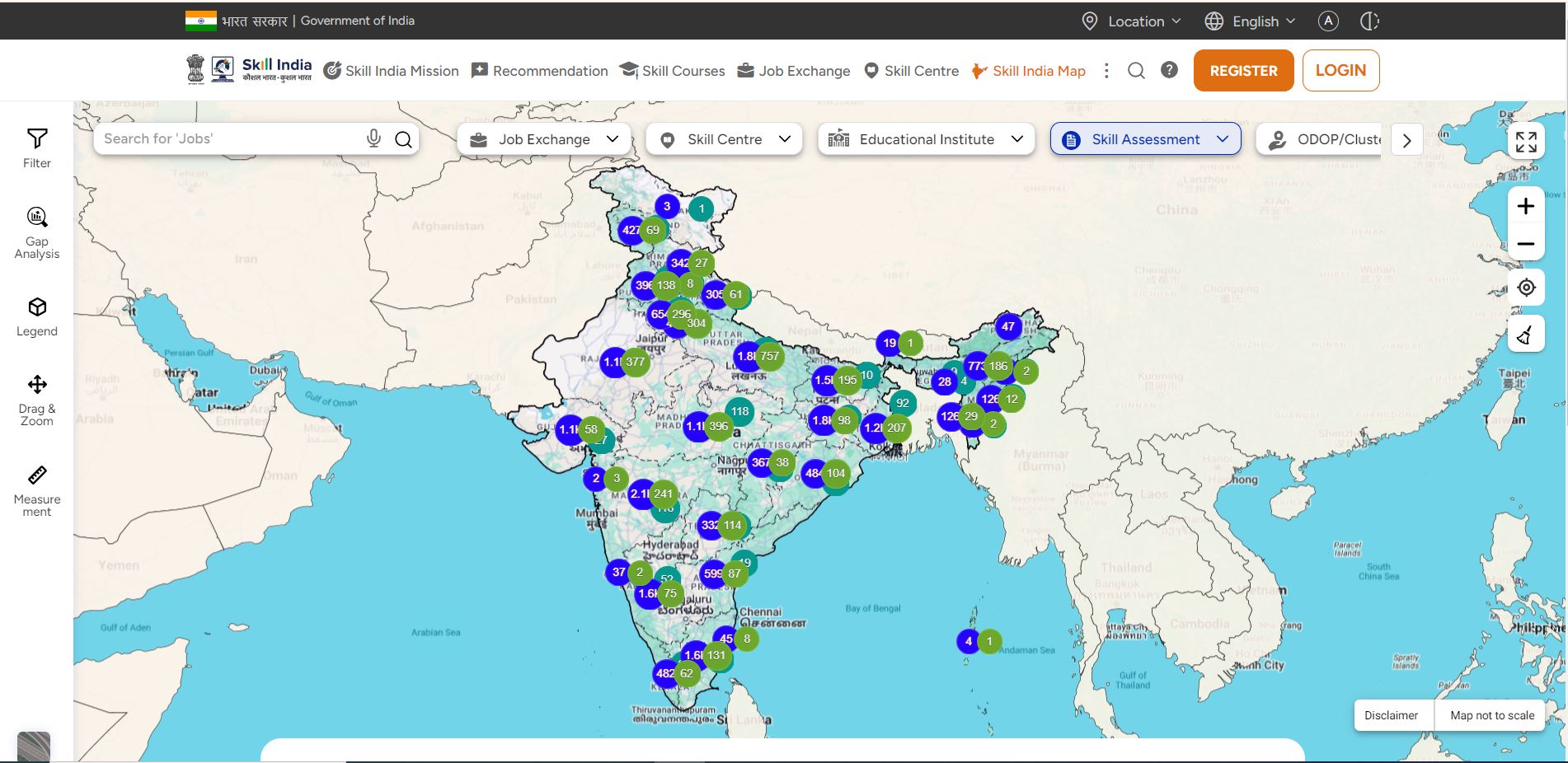
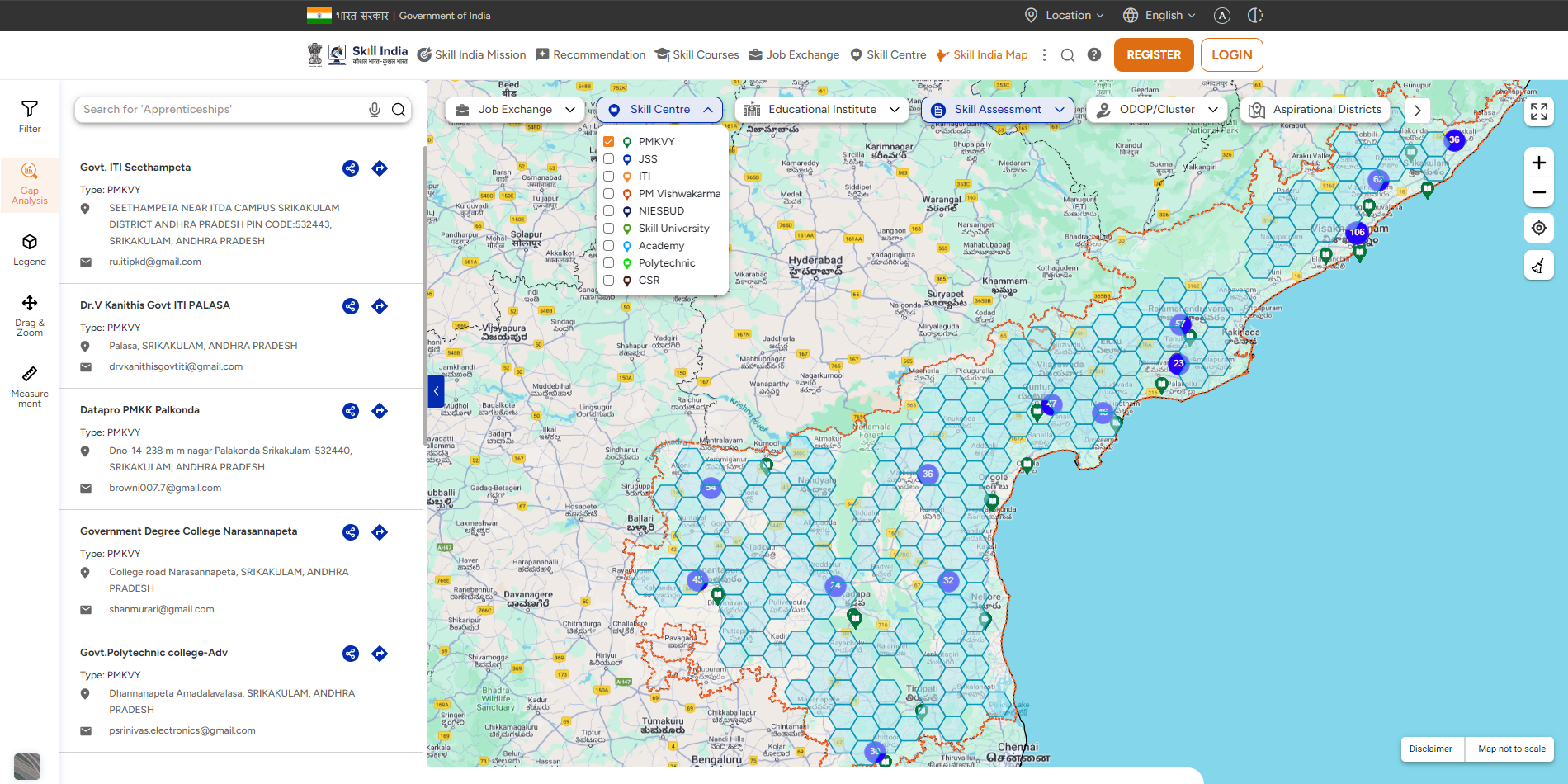
Innovative use of geospatial technology by ML Infomap in the Skill India Digital project of National Skill Development Corporation facilitated accurate mapping of the skills ecosystem. It also empowered stakeholders with actionable insights for strategic planning and decision-making in the realm of access to quality skill development. Geospatial technology enabled real-time updates of skill development centres, training programs, and industry collaborations. This dynamic mapping ensured that the platform reflected the current state of the skills ecosystem, fostering accuracy, relevant opportunities, and entrepreneurial support. Use of GIS resulted in a breakthrough in accelerating skilled talent hiring, facilitating lifelong learning and career advancement.
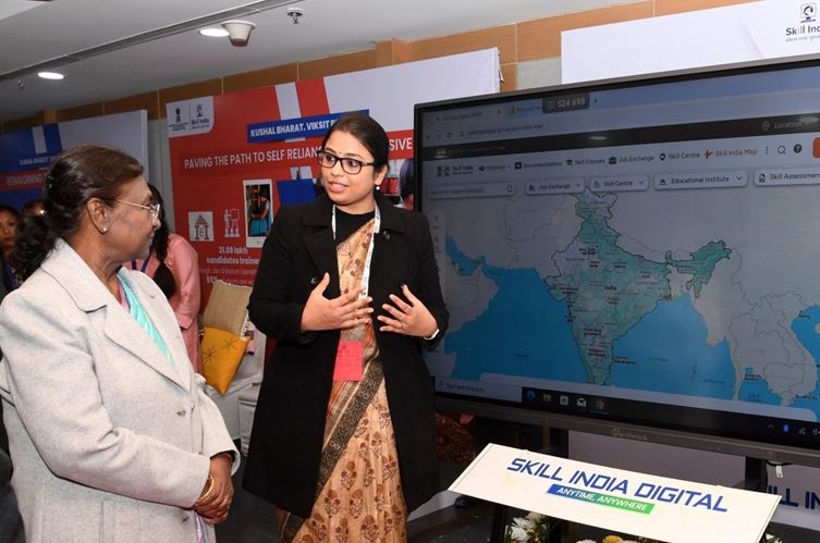
Hon’ble President of India, Smt. Draupadi Murmu, at the inauguration of Skills India Digital. Shreshtha Gupta, EVP NSDC, explaining salient features of mapping the skills ecosystem.
INDIA’S LARGEST COMPANY INDIANOIL USES GIS FOR FLEET MANAGEMENT
AGI Newsletter. Volume II. June 2019.Geospatial Technology For Safe Movement of LPG
Implemented in Tamil Nadu and Puducherry by ML Infomap, New Delhi.
‘… The success of this project depends on the ability to provide a robust end-to end integrated IT/GIS solution. All components, including GPS hardware, GIS software, navigation ready intelligent digital maps, voice triggers, telecommunication, geo-database, spatial analytics, SAP interface and text messaging, require working in sync in the Data Centre and Cloud. Reliance on the Internet for near real time data transfers also implies the availability of a good telecom service network across the area. IndianOil can monitor the entire fleet of trucks online. Transporters now view this as compliance more than surveillance. Drivers understand the certainty of being identified if deviating from approved routes and stopping on the way to deliver LPG.
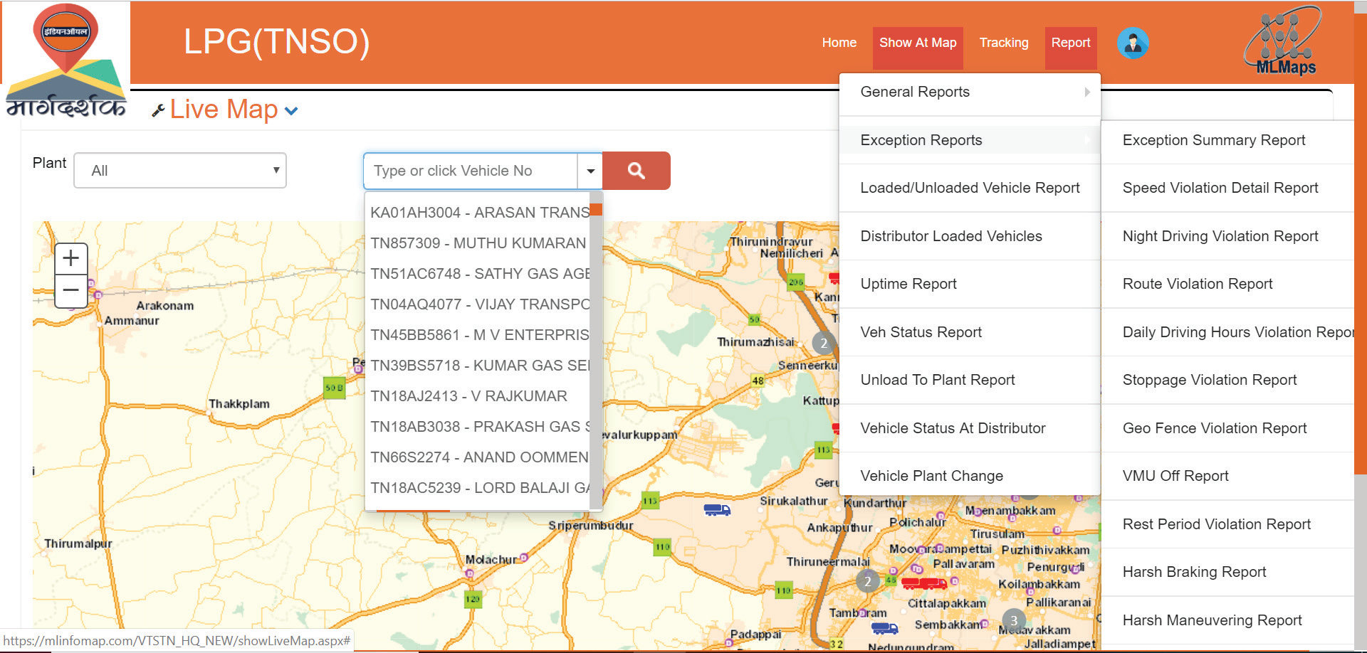
This project is ongoing, and the entire work is delivered under Service Delivery Model. It has already shown remarkable improvement in driving compliance and safety of movement of LPG in the state.’
REACHING HEALTHCARE TO REMOTE AREAS
Immunization Coverage & Vaccine Consumption In Rural India
Department of Science and Technology, Government of India Report: Indian Experience in Alignment with United Nations – Integrated Geospatial Information Framework, 2022. Example 45: Removing Institutional Silos in Immunisation Drives using GIS Triangulation.
ML Infomap developed the Immunization App to strengthen delivery of vaccines for 12 diseases in rural India. This innovative initiative was supported by Bill and Melinda Gates Foundation (BMGF) in partnership with Biotechnology Industry Research Assistance Council (BIRAC). It demonstrated porting public health data on a GIS platform to get good insights into distribution of vaccines from the last cold chain point to vaccination session sites, geographically extend vaccination to include all rural population clusters and create an automated system to monitor the efficacy of the Universal Immunization Programme on the ground. GIS was used to solve practical operational problems relating to each of these three aims, with a view to leave no one behind.
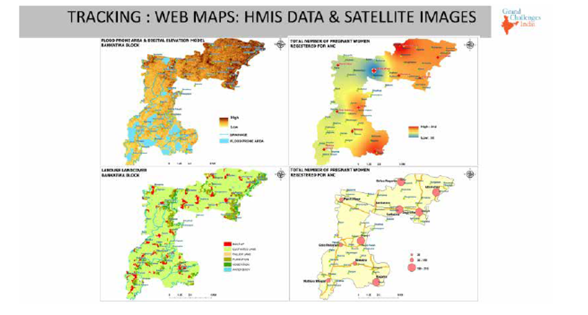
Integrative GIS Platform: A holistic picture appears using satellite images, HIMS, eVIN and census data.
GEOSPATIAL APP FOR MARKET DISCOVERY
Markets India
This market discovery app finds hidden markets and enables expansion geographically. Marketers value it because it focuses on sourcing and sales opportunities for six industry sectors in India. Powered by industry data, advanced analytics and cloud computing, it has tools for marking sales territories and site selection, make reports and maps on the fly. Contact us at post@mlinfomap.com for business specific customisation.
URBAN LOCAL BODIES USE GEO APP FOR WASTE COLLECTION
Swachh Nagar Engineer App
It was developed for Swachh Bharat Mission Urban of MoHUA, GOI. This app provides automated processes to the Urban Local Body (ULB) to effectively monitor door to door waste collection from households. It also helps ULB administrators get a single view of operations on the ground and communicate with citizens and waste collectors from the Web dashboard. It collects data from citizens, waste collectors, QR codes, etc. through mobile smart phones in real time
Our strong and capable team of IT/GIS professionals have high levels of academic distinction, skills and years of work experience.
